Look Out SpongeBob

Tuesday 12 January 2016

SEJARAH CAMEROON HIGHLAND

The Cameron Highlands (MalayTanah Tinggi Cameron) is one of Malaysia’s most extensive hill stations. The size of Singapore, it occupies an area of 712 square kilometres (275 sq mi). To the north, its boundary touches that ofKelantan; to the west, it shares part of its border with Perak.
Situated at the northwestern tip of Pahang, the “Camerons” is approximately 90 kilometres (56 mi) from Ipoh, about 200 kilometres (120 mi) from Kuala Lumpur or about 355 kilometres (221 mi) from Kuantan, the capital of Pahang. It is the smallest constituency in Pahang.
Discovered by Sir William Cameron in 1885, the outpost consists of three districts, namely Ringlet (5,165 hectares),Tanah Rata (2,081 hectares) and Ulu Telom (63,981 hectares). Its eight sub-districts are RingletTanah Rata (the administrative centre), Brinchang, the Bertam ValleyKea FarmTringkapKuala Terla and Kampung Raja. All are nestled at elevations ranging from 1,100 metres (3,600 ft) to 1,600 metres (5,200 ft) above sea level.
The mean annual temperature of the retreat is about 18 °C (64 °F). During the day, the temperature seldom rises over 25 °C (77 °F); at night, it rarely drops to as low as 9 °C (48 °F) at the higher reaches.[2]
The resort has a diverse population of more than 38,000 people. It comprises Bumiputeras (Malay (7,321); others (5,668)), Chinese (13,099), Indians (6,988), non-Malaysian citizens (5,193), and other nationalities (202).[3] Most of the residents here are entrepreneurs, service industry employees, farm workers, retirees or government servants. The languages spoken are MalayMandarinTamil and EnglishIslamBuddhismTaoismHinduismChristianity andSikhism are the main religions of the haven.
Developed in the 1930s, the tableland is one of the oldest tourist spots in Malaysia. Apart from its tea estates, the plateau is also noted for its cool weather, orchardsnurseriesfarmlandswaterfallsriverslakeswildlifemossy forestgolf coursehotelsplaces of worshipbungalowsLand Roversmuseum and its aborigines (Orang Asli).


The Cameron Highlands can be accessed by road via TapahSimpang PulaiGua Musang or Sungai Koyan. Tapahand Simpang Pulai are the two approaches from PerakGua Musang and Sungai Koyan are the entryways fromKelantan and Pahang, respectively.
farah and nani


                  HAPPY NEW YEAR

amirul haikal

Langkawi had long been at the periphery of, but closely associated with, the domain of the old kingdom of Kedah. Legend tells of a great snake ular-besar, the custodian of the Langkawi Islands, to which a new king of Kedah must sacrifice a virgin daughter whenever he first ascended the throne, or when a war was declared with another state.[9]
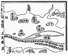
Mao Kun map from Wubei Zhi which is derived from the 15th century navigation maps of Zheng He showing Langkawi (龍牙交椅) next to Penang island (梹榔嶼)
The island of Langkawi was recorded in history by Chinese and other travellers. It was called Long-ya-pu-ti (龍牙菩提) by the Yuan Dynasty traveller Wang Dayuan , and when the Ming Dynasty admiral Zheng He visited the region he marked the island as Long-ya-jiao-yi (龍牙交椅). In the 15th century, it was known to Acehnese as Pulau Lada or Pepper Island as they came over to plant pepper. In 1691, the French general Augustin de Beaulieu recorded going to the island of "Lancahui" (Langkawi) to buy pepper,[7] and Beaulieu was required to obtain a license from Kedah's heir apparent then in Perlis before the penghulu or chief of Langkawi would sell pepper to him.[10]
Langkawi was historically home to seafarers, such as the Orang Laut (sea people) originally from the southern part of the Malay peninsula, as well as pirates and fishermen. It had been thought to be cursed for a couple of centuries - according to local legend, in the late 18th century, a woman named Mahsuri was wrongfully accused of adultery and put to death, and she placed a curse on the island that would last for seven generations.[11] Not long after Mahsuri's death, in 1821, the Siamese army invaded Kedah, and attacked Langkawi. In the first attack, the locals decided to burn down the granary atPadang Matsirat to starve and drive out the Siamese army. The Siamese nevertheless finally captured the island in May 1822, killed its leaders, and many of the islanders were taken as slaves, while others were forced to flee.[12] Before the Siamese invasion, there was an estimated island population of 3,000–5,000, and only a small proportion was left after the invasion.[13]
The island was recaptured from Siamese rule in a campaign against the Siamese in 1837. In 1840–1841, the Sultan of Kedah, who went into exile after the Siamese attacks, was allowed to return by the Siamese, and the population of Langkawi islands recovered afterwards mainly due to settlement of immigrants from Sumatra. However, the Orang Laut who fled after the Siamese attacks did not returned.[14] In 1909, the islands came under British rule under the Anglo-Siamese Treaty of 1909. The middle of the channel between Tarutao and Langkawi would become the Siamese border, and Tarutao would be part of Siam while all the Langkawi islands to the south would come under British rule. During the Second World War, Siam took control briefly as Malaya fell to the Japanese.
Langkawi had been a haven for pirates which affected the northern part of the Malacca Strait. In a series of operations, between December 1945 and March 1946, the British cleared the pirates' land base in Langkawi and Tarutao.[15] The British continued to rule until Malaya gained its independence in 1957.
Langkawi remained as a quiet backwater until 1986, when the then Prime Minister Mahathir Mohamad decided to transform it into a major tourist resort, helping to plan many of the islands buildings himself.[16] The island rapidly grew as a tourist destination, and by 2012, it had received over 3 million tourists a year.[17][18]


Geography[edit]

Sunday 27 December 2015

Afnan

Published In 27.Disember.2015.

Happy New Year 2016.

Thank You of 4 Genius 2015


Monday 14 December 2015

Thursday 19 November 2015

Hafiz Rosli and Afnan Zafran 3


Malacca (MalayMelaka), dubbed "The Historic State", is a state in Malaysia and located in the southern region of the Malay Peninsula, next to the Straits of Malacca.
It borders Negeri Sembilan to the north and Johor to the south. The capital is Malacca City, which is 148 kilometres (92 miles) south east of Malaysia's capital city Kuala Lumpur, 235 kilometres (146 miles) north west of Johor's largest city Johor Bahru, and 95 km (59 miles) north west of Johor's second largest city, Batu Pahat. This historical city centre has been listed as a UNESCO World Heritage Site since 7 July 2008.
Although it was the location of one of the earliest Malay sultanates, the local monarchy was abolished when the Portuguese conquered it in 1511. The head of state is the Yang di-Pertua Negeri or Governor, rather than aSultan.